
Connecting UTM with 3GPP MPS: Integrating Drone Traffic Management with Mobile Positioning Systems

Connecting UTM with MPS: The Intersection of Drones and Telecom Networks
The emergence of unmanned aerial systems (UAS), or drones, has brought about a mix of new challenges and opportunities in managing airspace. To ensure these systems operate safely and in a coordinated manner within the national airspace, we need strong communication, positioning, and tracking capabilities.
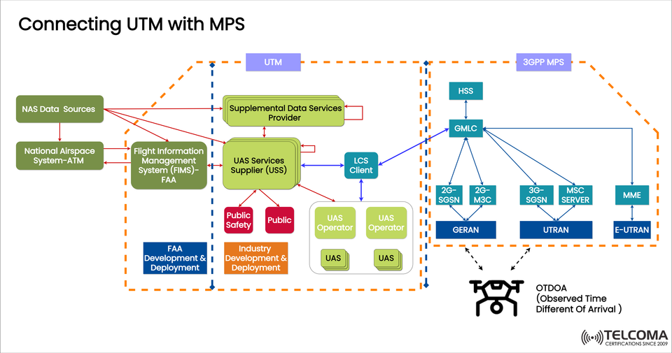
The image titled “Connecting UTM with MPS” gives a clear view of how Unmanned Traffic Management (UTM) systems work together with 3GPP Mobile Positioning Systems (MPS). This collaboration allows for accurate, real-time tracking of drones and ensures their safe operation.
This partnership merges the aviation and telecom sectors, bringing together the efforts of the Federal Aviation Administration (FAA), UAS operators, and mobile network providers to keep drones functioning safely alongside manned aircraft.
Understanding UTM and MPS
What is UTM (Unmanned Traffic Management)?
UTM is a digital framework designed to oversee drone operations in low-altitude airspace. It includes:
Flight planning
Airspace authorization
Conflict management
Tracking and communication between drones and air traffic authorities.
The FAA’s Flight Information Management System (FIMS) is a key player here, facilitating data exchange between UAS Service Suppliers (USS), public safety agencies, and the National Airspace System (NAS).
What is MPS (Mobile Positioning System)?
The 3GPP Mobile Positioning System (MPS) utilizes cellular network technologies (2G, 3G, 4G, and 5G) to pinpoint the geographic location of a mobile device—or in this case, a drone with a cellular module.
Some important features include:
Network-based positioning (like OTDOA, E-CID, A-GNSS)
High accuracy
Low latency
Nationwide coverage
When UTM connects to MPS, drones gain the advantage of telecom-grade positioning accuracy and real-time location updates, which are crucial for safe operations in shared airspace.
Breaking Down the Architecture
The diagram splits the ecosystem into two main areas:
UTM Domain (left): This side focuses on managing drone operations, coordinating airspace, and exchanging data through FAA systems.
3GPP MPS Domain (right): This handles mobile positioning and communication using telecom networks.
✈️ Components of the UTM Domain
- NAS Data Sources
These sources provide national airspace data—like weather updates, restricted flight zones, and traffic alerts—to the Flight Information Management System (FIMS). This helps ensure that all drone operations stay compliant with FAA regulations and current flight conditions.
Flight Information Management System (FIMS) – FAA
The FIMS serves as the FAA's platform for managing UAS operations. It collaborates with:
UAS Service Suppliers (USS)
Supplemental Data Service Providers (SDSP)
Public safety agencies
Key Functions of FIMS:
Coordinates access to airspace
Authorizes flight plans
Shares situational awareness among UTM participants
Supplemental Data Services Provider (SDSP)
The SDSP offers extra data, such as:
Weather forecasts
Terrain and obstacle maps
Communications coverage information
These details help UAS operators plan safer and more efficient flight paths.
UAS Services Supplier (USS)
This is the main operational hub within UTM. The USS takes care of:
Flight planning and authorization
Conflict detection and avoidance
Data exchange between the FAA and drone operators
It interacts directly with:
Public safety organizations
Industry stakeholders
UAS operators
UAS Operators and UAS (Drones)
Operators use UTM tools (through USS) to manage their drone missions. Each UAS (Unmanned Aircraft System) comes with communication and positioning modules that allow it to send telemetry data and receive commands in real-time.
LCS Client (Location Services Client)
The LCS Client acts as the link between the UTM and MPS domains. It requests location data from telecom networks (through MPS) for drones operating under a specific USS.
In simple terms, it allows UTM systems to ask the mobile network for a drone's current position.
Components of the 3GPP MPS Domain
GMLC (Gateway Mobile Location Center)
The GMLC is the core entity in charge of processing location requests. When the LCS Client sends a query, the GMLC:
Fetches the drone's location from the underlying RAN components (GERAN, UTRAN, E-UTRAN)
Integrates data from HSS, MME, and other network functions
Sends accurate location information back to the UTM
HSS (Home Subscriber Server)
The HSS verifies the drone’s SIM or network identity and provides necessary subscriber data for secure location access.
GERAN, UTRAN, E-UTRAN
These represent the radio access networks across different generations:
GERAN (2G)
UTRAN (3G)
E-UTRAN (4G LTE)
Each network layer can perform location measurements using techniques such as:
OTDOA (Observed Time Difference of Arrival)
A-GPS (Assisted GPS)
Cell-ID-based positioning
OTDOA – Observed Time Difference of Arrival
In this approach, the network figures out a device's position based on the time differences in signal arrival at various base stations.
It provides meter-level accuracy, making it great for:
Drone navigation
Geofencing enforcement
Collision avoidance
MME, SGSN, and MSC Server
These entities manage control-plane signaling:
MME (Mobility Management Entity) – For LTE-based tracking
SGSN (Serving GPRS Support Node) – For 2G/3G networks
MSC Server – For circuit-switched domains
All of these forward location requests and results to the GMLC, ensuring multi-generation support.
How UTM and MPS Integrate
Here’s how the data and control flow connects both domains:
NAS Data Sources and FIMS provide flight and airspace info to the USS.
UAS operators plan their missions via USS, which collaborates with the LCS Client for live location updates.
The LCS Client sends location requests to the GMLC within the 3GPP MPS network.
GMLC collects location data from MME, SGSN, and radio networks using OTDOA or similar methods.
This location information is sent back to the LCS Client, then to USS and FIMS for tracking and airspace coordination.
Public safety and industry systems receive updates for situational awareness and emergency management.
Key Benefits of UTM–MPS Integration
Benefit Description Nationwide Coverage Uses existing cellular networks for scalable drone tracking. High Accuracy Utilizes OTDOA and A-GPS for precise positioning. Real-Time Updates Continuous communication through LTE or 5G ensures near-instant tracking. Public Safety Integration Allows monitoring of drone activities in restricted areas. Regulatory Compliance Ensures operations meet FAA and national airspace regulations.
Looking Ahead: The Future of UTM and Telecom Collaboration
As drone traffic continues to increase, the partnership between UTM and MPS will grow stronger:
5G Ultra-Reliable Low-Latency Communication (URLLC) will boost responsiveness for autonomous drones.
Network slicing will allocate virtual resources for reliability in aviation-grade operations.
AI-driven flight analytics will automate route optimization and detect anomalies.
Future UTM systems will heavily depend on cloud-native 5G cores, edge computing, and MEC-based data fusion for advanced aerial operations.
Conclusion
The combination of Unmanned Traffic Management (UTM) with 3GPP Mobile Positioning Systems (MPS) marks a significant advancement in the development of drone ecosystems. By merging FAA flight management systems with telecom-grade positioning, this framework ensures safe, scalable, and smart airspace coordination.