
Positioning of User Equipment in LTE and WCDMA Networks with GPS Support

Positioning User Equipment in LTE and WCDMA Networks Using GPS
Getting an accurate fix on user devices (UEs) is crucial for today’s cellular networks. Whether it’s for navigation or emergency calls, telecom operators must reliably know where their UEs are located. By combining LTE (Long Term Evolution), WCDMA (Wideband Code Division Multiple Access), and GPS (Global Positioning System), we can create a solid system for determining UE positions.
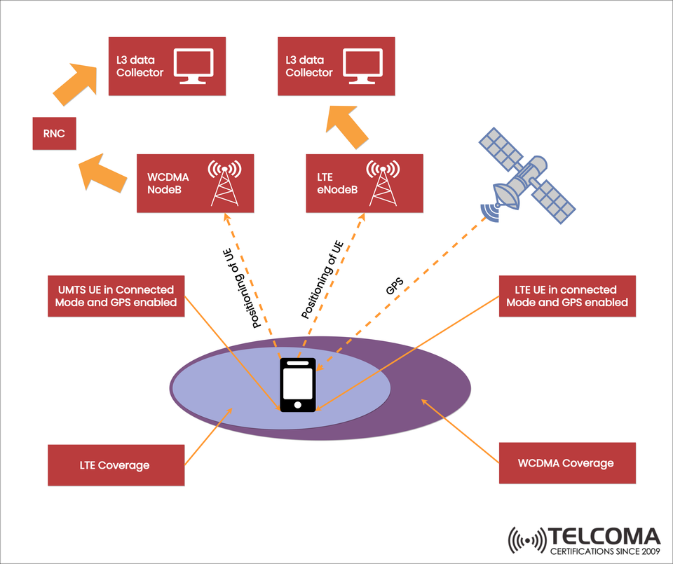
The diagram shows how a UMTS UE (Universal Mobile Telecommunications System) and LTE UE in connected mode with GPS turned on interact with WCDMA NodeB, LTE eNodeB, satellites, and L3 data collectors to track locations accurately.
Why UE Positioning Is Important in Telecom Networks
Positioning isn’t just for navigation apps; it has several significant roles in telecom:
Emergency services – Regulations (like E911 in the U.S.) require accurate location tracking for emergency calls.
Location-based services (LBS) – Services like maps, ride-hailing apps, and targeted ads heavily depend on precise positioning.
Network optimization – Operators utilize positioning data to analyze traffic, improve handovers, and plan capacity.
Security and surveillance – Positioning data aids in fraud detection, lawful interception, and tracking mobility.
Components of the UE Positioning System
The image highlights some key elements involved in positioning for LTE and WCDMA:
- User Equipment (UE)
UMTS UE in connected mode with GPS turned on.
LTE UE in connected mode with GPS turned on.
Both rely on signals from cellular base stations and GPS satellites for their position.
- WCDMA NodeB
The NodeB (the base station in WCDMA) interacts with the UE to gather radio measurements.
It sends this collected data to the RNC (Radio Network Controller) for further processing.
Helps positioning by measuring timing, signal strength, and angle-of-arrival.
- LTE eNodeB
The LTE base station is directly involved with positioning systems.
It provides timing advance, cell IDs, and measurement reports.
Works alongside GPS and communicates with L3 data collectors for accurate mapping.
- GPS Satellites
Supply global positioning data directly to the UE.
GPS is highly accurate but can struggle indoors or in obstructed areas.
Cellular assistance enhances GPS performance, especially in weak-signal zones.
- L3 Data Collectors
Gather measurement and signaling data from the network.
Help analyze UE positioning for coverage and mobility studies.
Give operators insights on user distribution, performance, and Quality of Service (QoS).
- RNC (Radio Network Controller)
Manages NodeBs in WCDMA networks.
Takes care of mobility, signaling, and forwards data to higher-layer systems.
Positioning Methods in LTE and WCDMA
Positioning systems use different techniques to ensure accuracy. Using both cellular and satellite methods makes them more reliable.
Method | Technology Used | Accuracy | Use Case
Cell ID | WCDMA / LTE | 100m – 1km | Basic coverage area detection
Timing Advance | LTE, WCDMA | 50 – 200m | Handover support, mobility tracking
OTDOA (Observed Time Difference of Arrival) | LTE | 50 – 150m | Network-based positioning
GPS / A-GPS | Satellite + Network Assistance | 5 – 50m | Navigation, emergency services
Hybrid (Cellular + GPS) | LTE & WCDMA + GPS | <10m | Most accurate, used in LBS
How the Process Works (Step-by-Step)
UE in Connected Mode: The UE (either LTE or UMTS) stays connected, exchanging data with NodeB/eNodeB.
GPS Positioning: The UE picks up GPS signals coming straight from satellites.
Cellular Measurements: NodeB/eNodeB collects positioning-related metrics (timing, signal strength, etc.).
Data Transmission: These measurements get sent to the RNC (in WCDMA) or directly to L3 Data Collectors (in LTE).
Analysis: L3 Data Collectors combine GPS data and network measurements to pinpoint UE locations accurately.
LTE vs WCDMA Positioning: Key Differences
LTE allows for a more integrated positioning approach through eNodeB and OTDOA, giving it better accuracy.
WCDMA coordinates more through the RNC, resulting in slightly less accuracy compared to LTE.
Hybrid LTE + GPS offers top-tier accuracy, especially in urban settings.
Challenges in UE Positioning
Even with improvements, there are still challenges to overcome:
Indoor positioning – GPS signals weaken indoors, needing help from Wi-Fi or small cells.
Latency – Real-time applications require low-latency updates for positioning.
Battery consumption – GPS can drain UE batteries quickly; hybrid approaches help optimize usage.
Handover impact – To maintain seamless mobility, positioning updates are crucial during inter-RAT (Radio Access Technology) handovers.
Future of UE Positioning: 5G and Beyond
While we’ve focused on LTE and WCDMA here, 5G is set to bring exciting upgrades:
NR positioning reference signals (PRS) – These dedicated signals boost accuracy.
Multi-RTT (Round Trip Time) measurements.
Integration with IoT and V2X (Vehicle-to-Everything) applications.
Centimeter-level accuracy for fields like autonomous driving, smart cities, and industrial automation.
Key Takeaways
Positioning in LTE and WCDMA merges GPS with measurements from cellular networks.
NodeB, eNodeB, RNC, and L3 data collectors are all key players in this system.
The best accuracy comes from combining GPS and cellular methods.
Applications range from emergency services to navigation, LBS, and optimizing networks.
Upcoming networks like 5G are set to take positioning accuracy to new heights.
Conclusion
Positioning UEs in LTE and WCDMA networks is made possible through a mix of GPS signals, cellular measurements, and L3 data collection. This hybrid strategy promotes accuracy, reliability, and scalability for telecom services. While WCDMA relies more on RNC coordination, LTE directly integrates positioning in eNodeBs, making it more efficient and accurate. As networks continue to evolve, the importance of positioning will only grow, inspiring advancements in 5G and beyond, especially for sectors like autonomous vehicles, emergency response, and smart cities. Understanding the intricacies from UE measurements to L3 data gathering gives telecom professionals and enthusiasts the necessary insights to appreciate and enhance positioning systems.