
Understanding 5G DL-PRS Resource Sets: AOD, ZOD, and Polar Coordinates in 3GPP Release 16

Introduction: The Science Behind 5G’s Precision Positioning
One of the game-changing features of 5G technology is its ability to pinpoint user equipment (UE) in real-time with incredible accuracy. This ultra-precise positioning opens the door to essential applications like autonomous driving, robot navigation, emergency response, and industrial IoT.
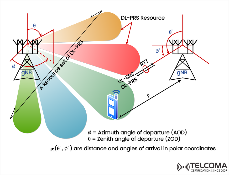
The image above shows the concept behind the Downlink Positioning Reference Signal (DL-PRS) and its resource sets, which are crucial for angle-based positioning methods highlighted in 3GPP Release 16.
By gaining insights into parameters like Azimuth Angle of Departure (AOD), Zenith Angle of Departure (ZOD), and polar coordinate mapping, telecom engineers can grasp how 5G achieves centimeter-level accuracy.
What is DL-PRS in 5G?
Definition and Role
DL-PRS (Downlink Positioning Reference Signal) is a unique reference signal sent out by the gNB (5G base station) to support downlink-based positioning for the UE.
It’s a part of the NR (New Radio) positioning framework introduced in 3GPP Release 16.
DL-PRS signals are transmitted over specific resource sets, which are predefined time-frequency blocks that focus on positioning instead of communication.
Why DL-PRS Matters
DL-PRS serves as the backbone for techniques like:
Time Difference of Arrival (TDOA)
Angle of Arrival (AOA)
Angle of Departure (AOD)
Round Trip Time (RTT)
These methods can help 5G networks determine a device’s position with astonishing accuracy, even in non-line-of-sight (NLOS) scenarios or crowded urban settings.
Understanding the Image: A Resource Set of DL-PRS
The image depicts two gNBs sending out DL-PRS signals to a UE. Each gNB transmits beams in various spatial directions, shown as colorful lobes. These beams relate to the AOD and ZOD parameters, which detail how and where the signal is broadcast.
Key Elements:
DL-PRS Resource Set
A resource set is a collection of DL-PRS resources allocated for the UE.
Each resource specifies a distinct time, frequency, and beam setup.
Collectively, they cover various spatial angles for precise triangulation.
Angles of Departure
Azimuth Angle of Departure (AOD, denoted as ∅): The horizontal angle at which the DL-PRS signal exits the gNB’s antenna array.
Zenith Angle of Departure (ZOD, denoted as θ): The vertical angle of the signal’s departure concerning the ground.
Polar Coordinates
The UE’s position is represented in polar coordinates (ρ₁(θ’, ∅’)), where:
ρ = radial distance (range)
θ’ = zenith angle of arrival
∅’ = azimuth angle of arrival
These measurements allow the gNB and UE to accurately estimate the UE’s 3D location.
Round Trip Time (RTT) and Uplink SRS
UL-SRS (Uplink Sounding Reference Signal) is sent by the UE for uplink-based calculations.
RTT (Round Trip Time) determines the distance based on the time delay between sent and received signals.
Together, these metrics facilitate exact multilateration and angle-based triangulation.
How 5G Uses AOD and ZOD for Positioning
Step 1: Signal Transmission
The gNB sends out DL-PRS beams across various AOD and ZOD combinations.
Each beam represents a particular direction, creating a “beam sweep” that covers the entire sector.
Step 2: Signal Reception
The UE assesses the signal strength, timing, and arrival angles (θ’, ∅’) of the incoming beams.
These factors help identify which beam—or direction—offers the strongest signal.
Step 3: Position Estimation
The network or UE calculates the distance (ρ) using RTT or TDOA.
By combining this data with AOD/ZOD information, they can achieve precise 3D positioning.
This multi-angle and time-based approach allows for centimeter-level accuracy, especially when several gNBs are involved in the process.
DL-PRS Resource Configuration Parameters
Parameter Description Purpose
PRS Periodicity Time interval between DL-PRS transmissions Ensures regular positioning updates
PRS Resource ID Unique identifier for each resource set Differentiates resources from various gNBs
Beam Index Identifies the specific transmission beam Aids in beam-based AOD/ZOD estimation
Frequency Density Frequency spacing of PRS signals Enhances multi-path resolution
Time Offset Adjusts DL-PRS scheduling Optimizes coordination between gNBs
These configurations are managed dynamically by the LMF (Location Management Function) and AMF (Access and Mobility Management Function) for each positioning session.
The Role of Polar Coordinates in 5G Positioning
Unlike previous cellular systems that relied on basic latitude and longitude coordinates, 5G uses polar coordinates for a more precise 3D localization.
ρ (Rho): The distance between the UE and gNB.
θ (Theta): The zenith angle, indicating height.
∅ (Phi): The azimuth angle, indicating direction horizontally.
This coordinate system allows the network to:
Accurately map the UE’s exact position in 3D space.
Differentiate between height (altitude) and horizontal distance.
Provide support for indoor positioning (for example, in multi-story buildings).
Advantages of DL-PRS Based Positioning
- High Precision
Beam-based AOD and ZOD estimations enable centimeter-level accuracy, even in tricky environments.
- 3D Localization
Unlike traditional 2D triangulation methods, DL-PRS allows for complete three-dimensional positioning.
- Efficient Resource Usage
Resource sets enable flexible positioning signal allocation without messing with data transmissions.
- Compatibility with Uplink Methods
DL-PRS (downlink-based) can work alongside UL-SRS (uplink-based) for better reliability.
- Robustness in Multipath Environments
Beamforming and polar mapping help isolate the line-of-sight path even with multiple reflections involved.
Real-World Applications of DL-PRS Positioning
Autonomous Vehicles: For accurate lane-level navigation and collision prevention.
Smart Factories: Monitoring robots, drones, and assets in real time.
Emergency Services: pinpointing UE locations for faster response.
Augmented Reality (AR): Enhancing spatial awareness for immersive experiences.
Telecom Network Optimization: Planning beams and resources based on user movement.
Comparison: DL-PRS vs Traditional Positioning
Feature DL-PRS (5G NR) LTE PRS (4G)
Accuracy <1 meter 50–100 meters
Dimension 3D (x, y, z) 2D only
Beamforming Supported Not supported
Coordination Multi-gNB resource sets Single eNB
Frequency Range Sub-6 GHz & mmWave Sub-3 GHz
Latency Ultra-low Moderate
This table showcases how 5G DL-PRS outperforms previous LTE positioning systems in terms of accuracy, speed, and dimensional detail.
Conclusion: DL-PRS Resource Sets — The Backbone of 5G Precision
The idea of DL-PRS resource sets in 3GPP Release 16 signifies a major shift towards highly accurate, three-dimensional, real-time positioning in 5G networks.
By utilizing azimuth (AOD) and zenith (ZOD) angles, polar coordinates, and advanced beamforming techniques, 5G networks can reach centimeter-level precision—a vital foundation for future advancements such as autonomous vehicles, smart cities, and immersive XR experiences.
As 5G continues to develop, positioning accuracy will enhance user interactions and transform how connected systems perceive, react, and engage with the physical environment.