
Understanding 5G Sidelink Positioning Reference Signals (SL-PRS) for V2X and Pedestrian Safety

Sidelink Positioning Reference Signals (SL-PRS): The Future of 5G Positioning in V2X and IoT
As 5G networks move towards Release 18 and 5G-Advanced, positioning is becoming a vital part of smart communication systems. Traditional positioning techniques depend a lot on network-based reference signals, but 5G brings in a more flexible and self-sufficient option — Sidelink Positioning Reference Signals (SL-PRS).
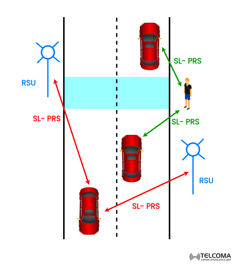
The image shared by Telcoma Global shows how vehicles, pedestrians, and roadside units (RSUs) can exchange SL-PRS signals to accurately figure out their positions, even when network coverage isn’t strong.
In this blog post, we’ll dive into what SL-PRS is, how it functions, its architecture, benefits, and how it changes the game for V2X (Vehicle-to-Everything) and IoT positioning.
What is Sidelink Positioning in 5G?
Sidelink (SL) is basically a direct communication channel between User Equipments (UEs) like vehicles, smartphones, and IoT devices. It works over the PC5 interface, letting devices share data without needing the base station (gNB).
This direct interaction is key for:
V2V (Vehicle-to-Vehicle)
V2P (Vehicle-to-Pedestrian)
V2I (Vehicle-to-Infrastructure)
V2N (Vehicle-to-Network)
With sidelink positioning, UEs swap positioning reference signals (PRS) to calculate distances, track movement, and gain spatial awareness. This helps vehicles and pedestrians know where each other are in real time, boosting safety and coordination.
What is SL-PRS?
Sidelink Positioning Reference Signals (SL-PRS) are specific signals sent over the sidelink interface to help with relative positioning and ranging between UEs.
Unlike traditional Downlink PRS (provided by the gNB), SL-PRS:
Is sent by UEs or RSUs, not the base station.
Allows peer-to-peer ranging between vehicles or from a vehicle to a pedestrian device.
Supports network-independent localization, making it perfect for situations out of network coverage.
Purpose of SL-PRS
Measure Time of Arrival (ToA) or Time Difference of Arrival (TDoA) between UEs.
Identify relative positioning in crowded city areas or highways.
Boost V2X communication reliability and accuracy in autonomous navigation.
Understanding the Image: SL-PRS in Action
The diagram illustrates SL-PRS-based communication involving vehicles, RSUs, and pedestrians.
Key Components in the Image:
RSU (Roadside Unit): A fixed point that sends or receives SL-PRS signals.
Vehicles: Communicate with one another and with the RSU using SL-PRS (indicated by red arrows).
Pedestrian UE (smartphone): Either receives or sends SL-PRS to the vehicles for safety warnings (shown with green arrows).
Scenario Breakdown:
Vehicle-to-RSU (V2I) — The vehicle sends SL-PRS to nearby RSUs for positioning updates.
Vehicle-to-Vehicle (V2V) — Cars exchange SL-PRS signals to gauge distances and paths.
Vehicle-to-Pedestrian (V2P) — A vehicle identifies a pedestrian’s location using SL-PRS, facilitating collision avoidance or proximity alerts.
This is how 5G-based cooperative positioning works, providing real-time spatial awareness for everyone on the road.
Technical Working of SL-PRS
The functioning of SL-PRS involves several steps that mix radio signal measurement with mathematical estimating.
Step 1: Signal Transmission
UEs regularly send SL-PRS sequences in set time-frequency resources. These sequences are synchronized and standardized, allowing for precise measurements.
Step 2: Signal Reception and Measurement
Receiving UEs (vehicles, pedestrians, or RSUs) measure:
Time of Arrival (ToA) — This tracks how long it takes for the signal to arrive.
Received Signal Strength Indicator (RSSI) — When paired with ToA, it helps determine distance.
Angle of Arrival (AoA) — This identifies direction using antenna arrays.
Step 3: Position Computation
The relative position between UEs is calculated with:
Trilateration or multilateration based on ToA or TDoA measurements.
Angle-based estimation using AoA or AoD (Angle of Departure).
Step 4: Data Fusion
At the end, data from different SL-PRS exchanges (V2V, V2P, V2I) are combined for better accuracy, reliability, and redundancy.
Benefits of Sidelink Positioning with SL-PRS
a) Network Independence
SL-PRS allows for positioning even when the gNB or network is down — great for remote roads or disaster areas.
b) High Accuracy
By combining ToA, TDoA, and AoA measurements, we achieve centimeter-level accuracy, especially when synchronized with RSUs.
c) Low Latency
With direct sidelink communication, updates happen in real-time, which is crucial for things like autonomous driving or pedestrian safety alerts.
d) Energy Efficiency
Localization based on UE reduces the burden on the core network and optimizes spectrum use.
e) Improved Safety
SL-PRS allows vehicles to recognize pedestrians or nearby vehicles that might be hidden due to obstacles — increasing safety in NLOS (Non-Line-of-Sight) situations.
Comparison: Network-Based vs. Sidelink-Based Positioning
Feature Network-Based PRS Sidelink-Based PRS (SL-PRS)Transmitter gNBUE or RSU Coverage Dependency Needs network Works with or without coverage Latency Higher (network involved)Low (direct communication)Use Case Mobile positioning, IoT trackingV2X, public safety, autonomous vehicles Accuracy High (cell-level)Very high (proximity-level)Scalability Centralized Decentralized & scalable
Applications of SL-PRS in 5G Networks
a) V2X Communication
SL-PRS is vital for 5G NR-V2X, where vehicles share information directly regarding:
Location coordinates
Velocity and acceleration
Road hazards or braking alerts
This contributes to cooperative driving and preventing collisions.
b) Pedestrian and Cyclist Safety (V2P)
Pedestrian devices (smartphones, wearables) can send out SL-PRS to alert nearby vehicles of their presence — useful in blind spots or low-visibility situations.
c) Smart Transportation Systems
RSUs equipped with SL-PRS can help with real-time traffic flow optimization, lane management, and autonomous intersection handling.
d) Industrial and Drone Positioning
In industrial settings, robots and drones can use SL-PRS for accurate indoor positioning when GPS signals might not be reliable.
e) Public Safety and Emergency Response
When the network is down, first responders can use SL-PRS to find each other, making rescue operations more coordinated.
Technical Advancements in 5G-Advanced (Release 18)
3GPP Release 18 brings in new sidelink features that enhance SL-PRS performance:
Higher frequency support (mmWave bands) for better spatial resolution.
Beam-based sidelink positioning which improves directionality.
Synchronization through GNSS or gNB help when available.
Dynamic SL resource management to reduce interference.
Use of AI-driven positioning algorithms to predict movement patterns.
These advancements pave the way for ultra-precise, low-latency, and robust location services in urban and industrial settings.
Challenges and Considerations
Even though SL-PRS presents groundbreaking advantages, there are some challenges that need attention:
Synchronization: UEs require precise time sync for accurate ToA/TDoA results.
Interference Management: Crowded environments need robust resource allocation methods.
Hardware Needs: Multiple antennas and signal processors might complicate UEs.
Security and Privacy: Position-related data exchanges need to be encrypted to prevent misuse.
Current 3GPP studies are focused on making SL-PRS more scalable, efficient, and compliant with privacy standards.
Conclusion
Sidelink Positioning Reference Signals (SL-PRS) mark a significant advancement in 5G-Advanced positioning technology.
By facilitating UE-to-UE and UE-to-RSU positioning without the network's help, SL-PRS guarantees high accuracy, low latency, and resilient communication — essential for V2X, public safety, and industrial automation.
The image beautifully illustrates this vision — vehicles, pedestrians, and RSUs swapping positioning signals, creating a safer, smarter, and better-connected world.